Garmin
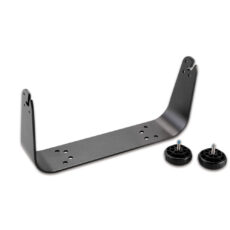
Garmin Bail Mount for GPSMAP 7408/7608
Surface mount your GPSMAP using our bail mount with knobs. The mount swivels and tilts for optimum viewing.
- Garmin
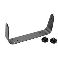
Garmin Bail Mount for GPSMAP 7416/7616
Surface mount your GPSMAP using our bail mount with knobs. The mount swivels and tilts for optimum viewing.
- Garmin
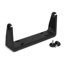
Garmin Bail Mount for GPSMAP 923
Surface mount your compatible GPSMAP device using our bail mount with knobs. The mount tilts for optimum viewing.
- Fishfinder / SonarGarmin
Garmin Bail Mount for STRIKER 9
Secure your compatible marine device with this mount, featuring tilt capabilities for optimum viewing.
- Garmin
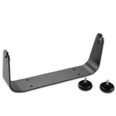
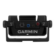
Garmin Bail Mount inc Knobs (GPSMAP 7×2 Series)
Surface mount your compatible GPSMAP using our bail mount with knobs. The mount tilts for optimum viewing.
- Garmin
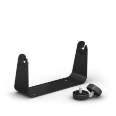
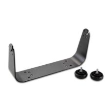
Garmin Bail Mount with Knobs (GPSMAP 1000 Series)
Surface mount your GPSMAP using this bail mount with knobs. The mount swivels and tilts for optimum viewing.
- Garmin
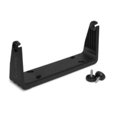
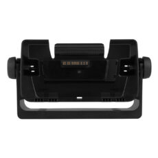
Garmin Bail Mount with Knobs (GPSMAP 12×2 Series)
Surface mount your compatible GPSMAP using our bail mount with knobs. The mount tilts for optimum viewing.
- Garmin
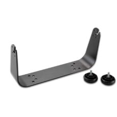
Garmin Bail Mount with Knobs (GPSMAP9x2 Series)
Surface mount your compatible GPSMAP using our bail mount with knobs. The mount tilts for optimum viewing.
- Garmin
Garmin Bail Mount with Knobs GPSMAP 7410 / 7610
Surface mount your GPSMAP using this bail mount with knobs. The mount tilts for optimum viewing.
- Garmin
Garmin Bail Mount with Quick Release Cradle for EchoMAP CHIRP 75dv
Surface mount your compatible ECHOMAP™ chartplotter/sounder combo using our bail mount with knobs; the mount tilts for optimum viewing. With the mount’s quick cable disconnect feature, you can plug the necessary cords into the mount, allowing you to seat/unseat your device with ease.
- Garmin
Garmin Bail Mount with Quick Release Cradle for EchoMAP CHIRP 75sv/92/95
Surface mount your compatible ECHOMAP™ chartplotter/sounder combo using our bail mount with knobs; the mount tilts for optimum viewing. With the mount’s quick cable disconnect feature, you can plug the necessary cords into the mount, allowing you to seat/unseat your device with ease.
- Garmin
Garmin Bar Mount for GPSMAP 276Cx
Take your Montana anywhere and everywhere with this handlebar mount. Simply snap your device – in any orientation, portrait or landscape – into the 22 to 32 mm rugged mount, which attaches to any standard bicycle handlebar, and it’s ready for your next cycling tour or mountain biking adventure. A molded rubber cushion is included in the kit to …
- Garmin
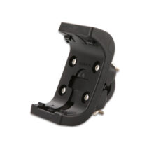
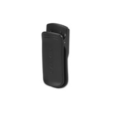
Garmin Belt Clip (Spine Mount)
Keep your compatible device within reach while on the move with this belt clip. Simply snap your device securely into the durable plastic mount and clamp it to your belt.
- Garmin
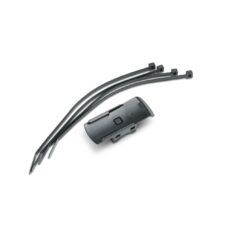
Garmin Bike/cart Mount
Use this mount to attach a compatible GPS unit (with spine mounting system) to any rail. The mount comes with 4 cable ties and can be fixed horizontally or vertically.
- Garmin
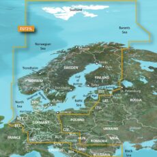
Garmin Blue Chart G3 Vision Large Area – VEU721L Northern Europe
Experience unparalleled coverage and brilliant detail when you’re on the water. BlueChart G3 Vision coastal charts provide industry-leading coverage, clarity and detail with integrated Garmin and Navionics content.
Compatible with the Garmin GPSMAP and ECHOMAP series Chartplotters.
- Garmin
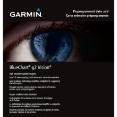
Garmin BlueChart g2 Vision Update Card
BlueChart g2 Vision enhances the most detailed electronic marine charting for European waters with deep water depth contours in the Fishing display, landmark points and features and numerous chart and notice-to-mariner updates.
- Garmin
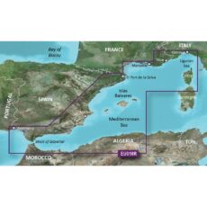
Garmin BlueChart G3 Regular Area – HXEU010R Spain, Mediterranean Coast
BlueChart g3 coastal charts provide industry-leading coverage, clarity and detail with integrated Garmin and Navionics data. Also included is Auto Guidance technology, which uses your desired depth and overhead clearance to calculate routes and provide a suggested path to follow — overlaid onto your chart. NOAA raster cartography is also available as a free downloadable feature via the ActiveCaptain app. …
- Garmin
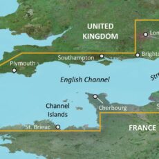
Garmin BlueChart G3 Regular Area – HXEU001R English Channel
BlueChart g3 coastal charts provide industry-leading coverage, clarity and detail with integrated Garmin and Navionics data. Also included is Auto Guidance technology, which uses your desired depth and overhead clearance to calculate routes and provide a suggested path to follow — overlaid onto your chart. NOAA raster cartography is also available as a free downloadable feature via the ActiveCaptain app. …
- Garmin
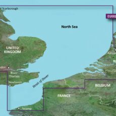
Garmin BlueChart G3 Regular Area – HXEU002R S/E England-Belux Inland Waters
BlueChart g3 coastal charts provide industry-leading coverage, clarity and detail with integrated Garmin and Navionics data. Also included is Auto Guidance technology, which uses your desired depth and overhead clearance to calculate routes and provide a suggested path to follow — overlaid onto your chart. NOAA raster cartography is also available as a free downloadable feature via the ActiveCaptain app. …
- Garmin
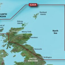
Garmin BlueChart G3 Regular Area – HXEU003R Great Britain, Northeast Coast
BlueChart g3 coastal charts provide industry-leading coverage, clarity and detail with integrated Garmin and Navionics data. Also included is Auto Guidance technology, which uses your desired depth and overhead clearance to calculate routes and provide a suggested path to follow — overlaid onto your chart. NOAA raster cartography is also available as a free downloadable feature via the ActiveCaptain app. …
- Garmin
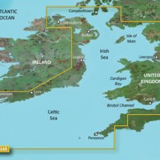
Garmin BlueChart G3 Regular Area – HXEU004R Irish Sea
BlueChart g3 coastal charts provide industry-leading coverage, clarity and detail with integrated Garmin and Navionics data. Also included is Auto Guidance technology, which uses your desired depth and overhead clearance to calculate routes and provide a suggested path to follow — overlaid onto your chart. NOAA raster cartography is also available as a free downloadable feature via the ActiveCaptain app. …
- Garmin
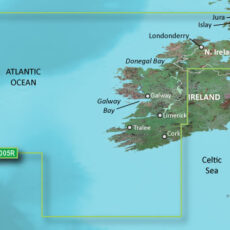
Garmin BlueChart G3 Regular Area – HXEU005R Ireland, West Coast
BlueChart g3 coastal charts provide industry-leading coverage, clarity and detail with integrated Garmin and Navionics data. Also included is Auto Guidance technology, which uses your desired depth and overhead clearance to calculate routes and provide a suggested path to follow — overlaid onto your chart. NOAA raster cartography is also available as a free downloadable feature via the ActiveCaptain app. …
- Garmin
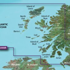
Garmin BlueChart G3 Regular Area – HXEU006R Scotland, West Coast
BlueChart g3 coastal charts provide industry-leading coverage, clarity and detail with integrated Garmin and Navionics data. Also included is Auto Guidance technology, which uses your desired depth and overhead clearance to calculate routes and provide a suggested path to follow — overlaid onto your chart. NOAA raster cartography is also available as a free downloadable feature via the ActiveCaptain app. …
- Garmin
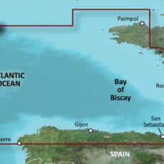
Garmin BlueChart G3 Regular Area – HXEU008R Bay of Biscay
BlueChart g3 coastal charts provide industry-leading coverage, clarity and detail with integrated Garmin and Navionics data. Also included is Auto Guidance technology, which uses your desired depth and overhead clearance to calculate routes and provide a suggested path to follow — overlaid onto your chart. NOAA raster cartography is also available as a free downloadable feature via the ActiveCaptain app. …
- Garmin
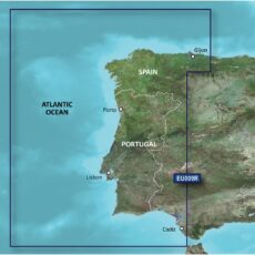
Garmin BlueChart G3 Regular Area – HXEU009R Portugal & Northwest Spain
BlueChart g3 coastal charts provide industry-leading coverage, clarity and detail with integrated Garmin and Navionics data. Also included is Auto Guidance technology, which uses your desired depth and overhead clearance to calculate routes and provide a suggested path to follow — overlaid onto your chart. NOAA raster cartography is also available as a free downloadable feature via the ActiveCaptain app. …
- Garmin
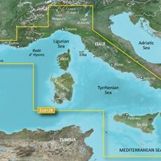
Garmin BlueChart G3 Regular Area – HXEU012R Mediterranean, Central-West
BlueChart g3 coastal charts provide industry-leading coverage, clarity and detail with integrated Garmin and Navionics data. Also included is Auto Guidance technology, which uses your desired depth and overhead clearance to calculate routes and provide a suggested path to follow — overlaid onto your chart. NOAA raster cartography is also available as a free downloadable feature via the ActiveCaptain app. …
- Garmin
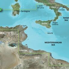
Garmin BlueChart G3 Regular Area – HXEU013R Italy Southwest & Tunisia
BlueChart g3 coastal charts provide industry-leading coverage, clarity and detail with integrated Garmin and Navionics data. Also included is Auto Guidance technology, which uses your desired depth and overhead clearance to calculate routes and provide a suggested path to follow — overlaid onto your chart. NOAA raster cartography is also available as a free downloadable feature via the ActiveCaptain app. …
- Garmin
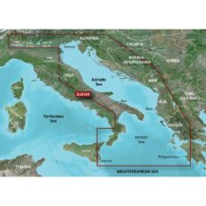
Garmin BlueChart G3 Regular Area – HXEU014R Italy, Adriatic Sea
BlueChart g3 coastal charts provide industry-leading coverage, clarity and detail with integrated Garmin and Navionics data. Also included is Auto Guidance technology, which uses your desired depth and overhead clearance to calculate routes and provide a suggested path to follow — overlaid onto your chart. NOAA raster cartography is also available as a free downloadable feature via the ActiveCaptain app. …
Garmin
Showing 113–140 of 889 results