Garmin
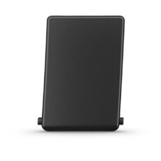
Garmin Micro SD Card Door (EchoMap 95sv)
Keep your compatible marine device at sea by securing and protecting your memory card with this microSD door.
- Garmin
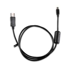
Garmin Micro USB Cable
Get the most out of your device using this microUSB cable to update your device software, download new vehicle icons and much more.
- GarminVHF Radio
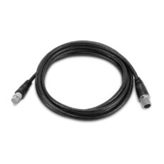
Garmin Microphone Extension Cable – 3m
Give yourself a little room when using your compatible VHF radio with this 12-pin fist mic extension cable.
- Garmin
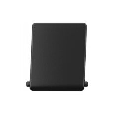
Garmin MicroSD Card Door for ECHOMAP Plus 75/UHD 75
Keep your compatible marine device at sea by securing and protecting your memory card with this microSD door.
- Garmin
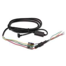
Garmin Mini USB Serial Power/Data Cable
Hardwire your Garmin to an electronic device to transfer speed and position data. You also can use our serial data/power cable to power your device. Input voltage range for this cable is 8 to 36 V. Note, for the Approach G3 and G5 products, only power is supplied, there is no data transfer.
- Garmin
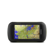
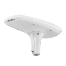
Garmin Montana 610
Designed for use on the trail, on road or on the water, the Montana 610 from Garmin will guide you wherever you go. With a vast 4” sunlight-readable touchscreen that offers crystal clear enhanced colours, dual orientation display and GPS and GLONASS positioning to track your location quicker and more accurately, even in the most challenging environment. It’s easy to …
- Garmin
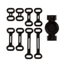
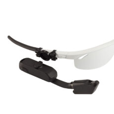
Garmin Mount and Bands for Nautix/Varia Vision
Secure your Varia Vision in-sight display or Nautix in-view display to your eye wear with this mount. Package includes mount and elastic bands for easy installation.
- Garmin
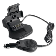
Garmin Mount with Power Cable and Speaker
Secure and power your device with this mount with power cable. External speaker provides audible voice prompts.
- Garmin
Garmin MSC 10 NMEA 2000 Marine Satellite Compass
Get reliable, accurate heading information with the easy-to-install GPS-based MSC™ 10 Marine Satellite Compass.
- Garmin
Garmin Nautix In-View Display
Garmin Nautix in-view display keeps important NMEA 2000® data in plain sight, no matter where your sight is directed on the boat or horizon.
Now you have a convenient reference that displays critical boat data at all times. Fishermen can keep an eye on water temperature or depth, boat speed and RPM. Sailors can watch the race start countdown …
- Garmin
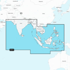
Garmin Navionics + Chart: AE010L – Indian Ocean & South China Sea
Coastal coverage of the South Asian coast and the Indian Ocean from Gwadar, PK to Da Nang, VN and the South China Sea. Includes India, Ceylon, Bangladesh, Myanmar, Thailand, Malaysia, Singapore, Cambodia, Indonesia, Brunei, the Philippines, the Andaman and Nicobar Islands, the Cocos Islands, Christmas Island, and the Maldives. Lakes Pangong and Spanggur are also covered.
- Garmin
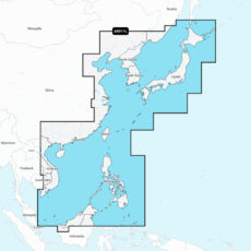
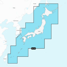
Garmin Navionics + Chart: AE011L – China Sea & Japan
Coastal coverage of the eastern Asian coast from Vladivostok, RU to the Mekong River Delta. Coverage includes the Japanese Islands, the Korean Peninsula, Taiwan, Brunei and the Philippines and the ports of Shanghai, Dalian, Hong Kong and Pusan.
- Garmin
Garmin Navionics + Chart: AE016R – Japan
Detailed coverage of coasts of Japan: from Yaeyama Islands, Okinawa to Aniva Bay and Kunashir Island. Coastal coverage of South Korea from Busan to Deoksan-ri. Includes detailed coverage of most major lakes including Inawashiro, Kussharo, Ogawara, Onuma, Shikotsu, Shinji, Towada, and Toyako.
- Garmin
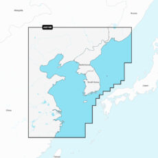
Garmin Navionics + Chart: AE018R – Yellow Sea
Coastal coverage of the East Asian coast from Vladivostok, RU to Shanghai, CH including the Korean Peninsula. Coverage includes the ports of Busan, South Korea and Dalian, China.
- Garmin
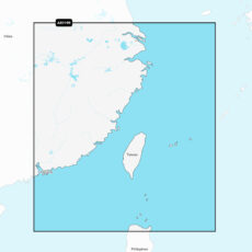
Garmin Navionics + Chart: AE019R – Taiwan
Coastal coverage includes mainland China from Shanghai to Hong Kong and Taiwan. Included in this coverage are detailed charts covering areas such as Macau, Keelong, Kaohsiung, Xiamen, and Guangzhou in China and Kaohsiung, Taichung City and Taipei in Taiwan.
- Garmin
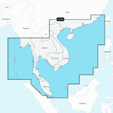
Garmin Navionics + Chart: AE020R – South China & Andaman Seas
Coastal coverage of the East Asian coast from Xiamen, China to Thailand including the coast of Vietnam, Cambodia, the Malay Peninsula, Hainan Island and the Andaman and Nicobar Islands. Included are detailed charts of such areas as Hong Kong and Macau; Phuket, Thailand; Singapore; Ho Chi Minh City, Vietnam and Guangzhou and Xiamen, China.
- Garmin
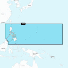
Garmin Navionics + Chart: AE021R – Philippines
Coastal coverage of the Philippine Islands and islands of Micronesia including the Marianas, Palau, Guam, Saipan and Wake Island.
- Garmin
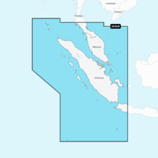
Garmin Navionics + Chart: AE022R – Sumatra
Coastal coverage of the Malay Peninsula from Phuket, Thailand to Singapore and portions of Indonesia including Java and the entire island of Sumatra. Coverage includes Christmas Island, the Cocos Islands and ports such as Jakarta, Indonesia and Malacca and Kuantan, Malaysia.
- Garmin
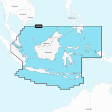
Garmin Navionics + Chart: AE023R – Java & Borneo
Coastal coverage of the central Indonesian islands and portions of Malaysia and the Philippines. Coverage includes Java, Borneo, Sulawesi and islands west of Timor, Brunei and the ports of Singapore, Jakarta and Davao City.
- Garmin
Garmin Navionics + Chart: AE024R – Central W Papua & E Sulawesi
Coastal coverage of Indonesia southeast and east of Sulawesi including East Timor and the ports of Surong, Manokwari, Manado, Makassar and Kendari.
- Garmin
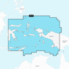
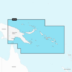
Garmin Navionics + Chart: AE025R – Papua New Guinea & Solomon Isl
Coastal coverage of Papua New Guinea and the Solomon Islands. Ports include Lae, Rabaul and Port Moresby, Papua New Guinea and Honaira, Solomon Islands.
- Garmin
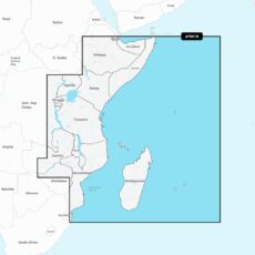
Garmin Navionics + Chart: AF001R – Africa, East
Coastal coverage of the east coast of Africa from Maputo Bay to the Horn of Africa, Zanzibar, Madagascar, Mauritius, Reunion and the Seychelles. Coverage includes the ports of Maputo, Mozambique; Dar es Salaam, Tanzania and Mombasa, Kenya.
- Garmin
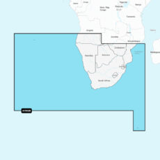
Garmin Navionics + Chart: AF002R – Africa, South
Coastal coverage of southern Africa from Namibe, Angola to the Zambezi Delta in Mozambique. Includes detailed coverage of Cape Town, Port Elizabeth, East London and Durban in South Africa and Maputo, Mozambique. Also includes coverage of the Tristan da Cunha Islands, St. Helena Island, Gough Island and the Prince Edward Islands.
- Garmin
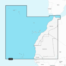
Garmin Navionics + Chart: AF004R – Africa, Northwest
Coastal coverage of the northwest coast of Africa from St Louis, Senegal to Rabat, Morocco. Detailed coverage of the Azores, Madeira, the Canary Islands, the Cape Verde Islands and the ports of Rabat and Casablanca, Morocco are included.
- Garmin
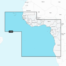
Garmin Navionics + Chart: AF005R – Africa, West
Coastal coverage of the west coast of Africa from Dakar, Senegal to Cape Cross Bay, Namibia. Detailed coverage of the Cape Verde Islands, Sao Tome and Principe, St Helena Island and Ascension Island and the ports of Dakar, Senegal; Lagos, Nigeria and Luanda, Angola are included.
- Garmin
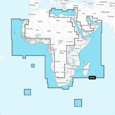
Garmin Navionics + Chart: AF630L – Africa & Middle East
Coastal coverage of the coast of Africa from Tripoli, Libya thru the Red Sea and around the Cape to Dakar, Senegal including the Suez Canal and the Levant, the coast of the Arabian Peninsula, the Persian Gulf, Madagascar, Socotra, Zanzibar, Reunion, Mauritius, the Seychelles, the Comoros, the Prince Edward Islands, Tristan de Cunha, St Helena Island, Ascension Island, the Cape …
- Garmin
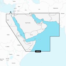
Garmin Navionics + Chart: AW010R – The Gulf & Red Sea
Coastal coverage of the Arabian Peninsula, the Red Sea and the Persian Gulf including the Suez Canal, the Gulfs of Aden and Oman, the coasts of Iran and Pakistan. Numerous detailed charts are included of areas such as Port Said, Egypt; Djibouti; Dubai; Bahrain and Karachi, Pakistan.
- Garmin
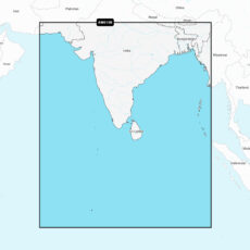
Garmin Navionics + Chart: AW015R – Indian Subcontinent
Coastal coverage of the Indian subcontinent from Pasni, Pakistan to Sittwe, Myanmar including Sri Lanka, the Andaman and Nicobar Islands, the Chagos Archipelago and the Maldives. Coverage includes ports such as Karachi, Pakistan; Calcutta and Mumbai, India and the Male Atoll.
Garmin
Showing 561–588 of 889 results