<style> @media only screen and (max-width: 1023px) { .block.upsell, .block.crosssell { display: none; } .ten { width: 15%; } } @media only screen and (min-width: 1024px) { .half td { width: 50%; } } .page-header, .product-image-wrapper, .navigation { z-index: 0; } .navigation:hover { z-index: 3; } .page-header:hover { z-index: 3; } .modalDialog { position: fixed; font-family: Arial, Helvetica, sans-serif; top: 0; right: 0; bottom: 0; left: 0; background: rgba(0, 0, 0, 0.8); z-index: 999; display: none; -webkit-transition: opacity 400ms ease-in; -moz-transition: opacity 400ms ease-in; transition: opacity 400ms ease-in; pointer-events: none; overflow-y: initial; } .modalDialog:target { display: block; pointer-events: auto; } .modalDialog>div { width: 100%; max-width: 1024px; height: 85%; position: relative; margin: 2% auto; padding: 0px; border-radius: 10px; background: #fff; background: -moz-linear-gradient(#fff, #999); background: -webkit-linear-gradient(#fff, #999); background: White; } .stop-button { background: #909090; color: #FFFFFF; line-height: 30px; font-size: 25px; position: absolute; right: 5px; text-align: center; top: 5px; width: 30px; text-decoration: none; font-weight: bold; -webkit-border-radius: 12px; -moz-border-radius: 12px; border-radius: 15px; -moz-box-shadow: 1px 1px 3px #000; -webkit-box-shadow: 1px 1px 3px #000; box-shadow: 1px 1px 3px #000; } .stop-button:hover { background: red; text-decoration: none; } #compatibility { border-collapse: collapse; width: 100%; } #compatibility td, #customers th { border: 1px solid #ddd; padding: 8px; } #compatibility tr:nth-child(even) { background-color: #f2f2f2; } #compatibility tr:hover { background-color: #ddd; } #compatibility th { padding-top: 12px; padding-bottom: 12px; text-align: left; background-color: #204387; color: white; } .modal-header { height: fit-content; padding: 1px; } .modal-title { text-align: center; } .modal-footer { height: fit-content; font-size: 1.2rem; background: #fff; border-radius: 10px; padding: 3px 3px 0 3px; } .modal-body { overflow-y: scroll; max-height: 90%; padding: 5px; } </style> <div id=”links”> <a class=”pagebuilder-button-primary” href=”#openModal” style=”text-align: center; font-weight: normal;”> <i class=”fas fa-wrench”></i> <span data-element=”link_text” style=”font-weight: 600;”> Specification</span> </a> <a class=”pagebuilder-button-primary” href=”https://www8.garmin.com/manuals/webhelp/GUID-900F784C-8371-433B-B263-67611C27A94C/EN-US/ECHOMAP_UHD2_6_7_9xsv_(Touch)_OM_EN-US.pdf” target=”_blank” style=”text-align: center; font-weight: normal;”> <i class=”fas fa-book”></i> <span data-element=”link_text” style=”font-weight: 600;”> Manual</span> </a> <a class=”pagebuilder-button-primary” href=”https://www8.garmin.com/manuals/webhelp/GUID-B4327979-40C0-487D-8117-A36D7AD0FA51/EN-US/ECHOMAP_UHD2_6_7_9xsv_(Touch)_Install_EN-US.pdf” target=”_blank” style=”text-align: center; font-weight: normal;”> <i class=”fas fa-wrench”></i> <span data-element=”link_text” style=”font-weight: 600;”> Installation</span> </a> <a class=”pagebuilder-button-primary” href=”https://static.garmin.com/pumac/ECHOMAP_UHD2_touch_6x_template.pdf” target=”_blank” style=”text-align: center; font-weight: normal;”> <i class=”far fa-file-image”></i> <span data-element=”link_text” style=”font-weight: 600;”> Template</span> </a> </div> <div id=”openModal” class=”modalDialog”> <div> <div class=”modal-header”> <h3 class=”modal-title”>Technical Specifications</h3> <a class=”stop-button” title=”Close” href=”#close” onclick=”go()”>X</a> </div> <div class=”modal-body”> <table id=”compatibility”> <thead> <tr> <th colspan=”2″><strong>General</strong></th> </tr> </thead> <tbody> <tr> <td>Dimensions</td> <td>20.6 x 13.1 x 6.7 cm (5.4″ x 5.2″ x 2.6″)</td> </tr> <tr> <td>Input</td> <td>Touchscreen with Keyed Assist</td> </tr> <tr> <td>Display Size</td> <td>13.8 x 7.8cm, 15.7cm Diagonal (5.4″ x 3.1″, 6.2″ Diagonal)</td> </tr> <tr> <td>Display Resolution</td> <td>800 x 480 Pixels</td> </tr> <tr> <td>Display Type</td> <td>WVGA, TN</td> </tr> <tr> <td>Weight</td> <td>0.8Kg (1.8lbs)</td> </tr> <tr> <td>Water Rating</td> <td>IPX7</td> </tr> <tr> <td>Mounting Options</td> <td>Bail or Flush</td> </tr> </tbody> </table> <br> <table id=”compatibility”> <thead> <tr> <th colspan=”2″><strong>Maps & Memory</strong></th> </tr> </thead> <tbody> <tr> <td>Accepts Data Cards</td> <td>1 MicroSD Card, Max 32GB</td> </tr> <tr> <td>Waypoints</td> <td>5,000</td> </tr> <tr> <td>Track Points</td> <td>50,000</td> </tr> <tr> <td>Tracks</td> <td>50 Saved Tracks</td> </tr> <tr> <td>Navigation Routes</td> <td>100</td> </tr> </tbody> </table> <br> <table class=”half” id=”compatibility”> <thead> <tr> <th colspan=”2″><strong>Sensors</strong></th> </tr> </thead> <tbody> <tr> <td>Has Built-In Receiver</td> <td class=”ten”>✓</td> </tr> <tr> <td>Receiver</td> <td>10Hz</td> </tr> <tr> <td>NMEA 2000 Compatible</td> <td class=”ten”>✓</td> </tr> <tr> <td>GPS</td> <td class=”ten”>✓</td> </tr> <tr> <td>GLONASS</td> <td class=”ten”>✓</td> </tr> <tr> <td>GALILEO</td> <td class=”ten”>✓</td> </tr> <tr> <td>BEIDOU</td> <td class=”ten”>✓</td> </tr> <tr> <td>Supports WAAS</td> <td class=”ten”>✓</td> </tr> <tr> <td>Supports Multi-Band, Multi Constellation GPS</td> <td class=”ten”>✓</td> </tr> </tbody> </table> <br> <table class=”half” id=”compatibility”> <thead> <tr> <th colspan=”2″><strong>Built-in Maps</strong></th> </tr> </thead> <tbody> <tr> <td>Built-in Auto Guidance+</td> <td>Yes (Via ActiveCaptain App)</td> </tr> <tr> <td>Garmin Navionics+ Inland & Coastal</td> <td>Yes</td> </tr> <tr> <td>Garmin Navionics+ (Coastal)</td> <td>Yes</td> </tr> <tr> <td>Garmin Navionics+ (Inland)</td> <td>Yes</td> </tr> <tr> <td>Tide Tables</td> <td>Yes</td> </tr> </tbody> </table> <br> <table class=”half” id=”compatibility”> <thead> <tr> <th colspan=”2″><strong>Optional Map Support</strong></th> </tr> </thead> <tbody> <tr> <td>Garmin Navionics+</td> <td class=”ten”>✓</td> </tr> <tr> <td>Garmin Navionics Vision+</td> <td class=”ten”>✓</td> </tr> <tr> <td>TOPO</td> <td class=”ten”>✓</td> </tr> <tr> <td>Standard Mapping</td> <td class=”ten”>✓</td> </tr> <tr> <td>Garmin Quickdraw Contours</td> <td class=”ten”>✓</td> </tr> </tbody> </table> <br> <table class=”half” id=”compatibility”> <thead> <tr> <th colspan=”2″><strong>Chartplotter Features</strong></th> </tr> </thead> <tbody> <tr> <td>AIS</td> <td class=”ten”>✓</td> </tr> <tr> <td>DSC</td> <td class=”ten”>✓</td> </tr> <tr> <td>Fusion-Link Compatible</td> <td class=”ten”>✓</td> </tr> <tr> <td>ActiveCaptain App Compatible</td> <td class=”ten”>✓</td> </tr> <tr> <td>Sailing Features</td> <td class=”ten”>✓</td> </tr> </tbody> </table> <br> <table class=”half” id=”compatibility”> <thead> <tr> <th colspan=”2″><strong>Sonar Features & Specifications</strong></th> </tr> </thead> <tbody> <tr> <td>Displays Sonar</td> <td>✓</td> </tr> <tr> <td>Power Output</td> <td>500W</td> </tr> <tr> <td>Traditional Sonar</td> <td>Built-in (Single Channel CHIRP, 50/77/83/200 kHz L.M.H CHIRP)</td> </tr> <tr> <td>ClearVu</td> <td>Built-in (260/455/800/1000/1200 kHz)</td> </tr> <tr> <td>SideVu</td> <td>Built-in (260/455/800/1000/1200 kHz)</td> </tr> <tr> <td>Panoptix Sonar</td> <td>✓</td> </tr> <tr> <td>LiveScope</td> <td>✓</td> </tr> </tbody> </table> <br> <table class=”half” id=”compatibility”> <thead> <tr> <th colspan=”2″><strong>Connections</strong></th> </tr> </thead> <tbody> <tr> <td>NMEA 2000 Ports</td> <td>✓</td> </tr> <tr> <td>Garmin Marine Network Ports</td> <td>1</td> </tr> <tr> <td>12 Pin Transducer Ports</td> <td>1</td> </tr> <tr> <td>Bluetooth Calling</td> <td>✓</td> </tr> <tr> <td>ANT+ Connectivity</td> <td>✓</td> </tr> <tr> <td>Garmin Wi-Fi Network</td> <td>✓</td> </tr> </tbody> </table> <br> <table class=”half” id=”compatibility”> <thead> <tr> <th colspan=”2″><strong>Electrical Features</strong></th> </tr> </thead> <tbody> <tr> <td>Power Input</td> <td>9 – 18 Vdc</td> </tr> <tr> <td>Typical Current Draw at 12 Vdc</td> <td>1.53A</td> </tr> <tr> <td>Max Current Draw at 12Vdc</td> <td>3.2A</td> </tr> <tr> <td>Max Power Usage at 10 Vdc</td> <td>18.4W</td> </tr> </tbody> </table> </div> </div> </div> </div>
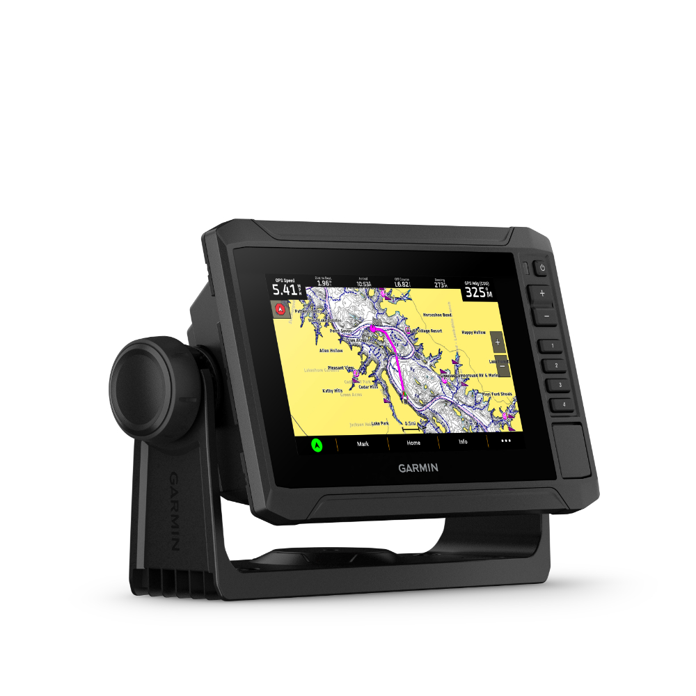
Know The Water Better Than A Local
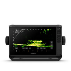
When it comes to catching more fish, they say, “talk to a local.” With the ECHOMAP UHD2 chartplotter, which offers support for Garmin’s best-in-class sonar, built-in Garmin Navionics+ for U.K and Ireland, and a premium touchscreen display with keyed-assist, know the water even better than they do.
It Doesn’t Get Any Better Than This
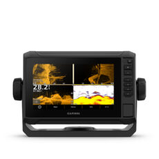
Sonar Support – With support for crisp, clear traditional sonar and brilliant ClearVü and SideVü scanning sonars, the fish will have nowhere to hide. The ECHOMAP UHD2 also supports LiveScope live-scanning sonar.
Vivid Colour Palettes – High-contrast vivid scanning sonar colour palettes make it easier than ever to distinguish targets and structure.
Preloaded Charts – Chartplotters come with built-in Garmin Navionics+ cartography for U.K., Ireland and the Netherlands which includes a 1-year subscription for daily updates, raster cartography and more.
Wireless Networking – Wirelessly share information such as sonar, waypoints and routes with another compatible ECHOMAP UHD2 chartplotter on the boat.
ActiveCaptain App – Built-in Wi-Fi connectivity pairs with the free all-in-one mobile app for access to the OneChart feature, smart notifications, software updates, Garmin QuickDraw Community data and more.
Auto Guidance Technology – Built-in Garmin Navionics+ charts for U.K., Ireland and the Netherlands include downloadable Auto Guidance+ technology with the ActiveCaptain app.
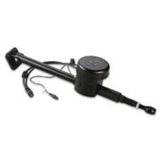
Troll With Force – The ECHOMAP UHD2 chartplotter wirelessly connects to Garmin Force Trolling Motors to create and follow routes, navigate to waypoints, control speed, check battery life and more.
Multi-Band GPS – Get improved position accuracy, particularly in areas where signals are reflected or weak, with multi-band GPS.
In The Box
- ECHOMAP UHD2 65sv
- 12-pin sounder to 8-pin transducer cable
- Power cable
- Tilt/swivel mount with quick release cradle
- Protective cover
- Hardware
- Documentation