Garmin
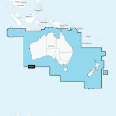
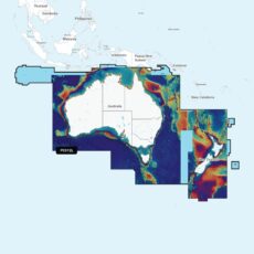
Garmin Navionics + Chart: PC012L – Australia & New Zealand
Detailed coverage of Australia, New Zealand and many associated islands. Coverage includes the Great Barrier Reef, Tasmania, Christmas Island, the Cocos (Keeling) Islands, Norfolk Island, Campbell Island, the Auckland Islands, the Antipode Islands, the Bounty Islands, the Chatham Islands and the Kermadec Islands. Ports include Sydney, Melbourne, Perth, Darwin and Cairns in Australia; Wellington, Auckland, Nelson and Dunedin in New …
- Garmin
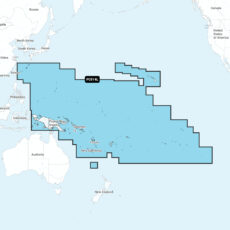
Garmin Navionics + Chart: PC014L – Pacific Islands
Detailed coverage of numerous islands in the Pacific Ocean. Coverage includes the Hawaiian Islands, the Ryukyu Islands, Papua-New Guinea and the Solomon Islands, New Caledonia, Fiji, Vanuatu, American Samoa, French Polynesia, Pitcairn Islands, the Marquesas Islands, Kiribati, Palau, the Marshall Islands and the Mariana Islands including Guam.
- Garmin
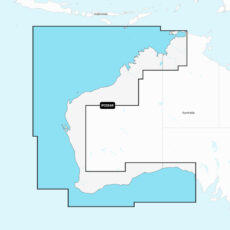
Garmin Navionics + Chart: PC026R – Australia, West
Detailed coverage of the northern and western coasts of Australia from Darwin to Ceduna. Includes coverage of Perth, Bunbury, Geraldton, Broome, Esperance, Dampier, Shark Bay and the Ashmore and Cartier Islands.
- Garmin
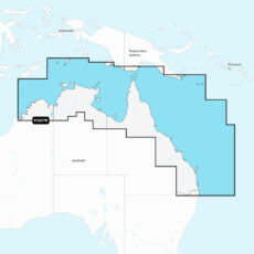
Garmin Navionics + Chart: PC027R – Australia, Northeast
Detailed coverage of northern and eastern Australia from Wolcott Inlet to Brisbane and the Gold Coast. Coverage includes the Great Barrier Reef, Darwin, Cairns and Port Moresby, Papua-New Guinea.
- Garmin
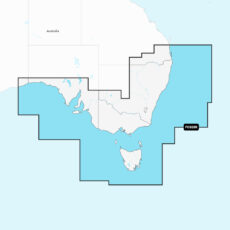
Garmin Navionics + Chart: PC028R – Australia, Southeast
Detailed coverage of the eastern and southern coast of Australia from Brisbane to Nullabor National Park. Coverage includes Tasmania and the ports of Adelaide, Melbourne and Sydney.
- Garmin
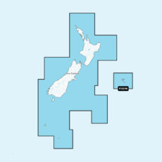
Garmin Navionics + Chart: PC029R – New Zealand
Detailed coverage of both North and South Island in their entirety. Coverage includes the Chatham Islands, the Bounty Islands, the Campbell Islands and the Auckland Islands.
- Garmin
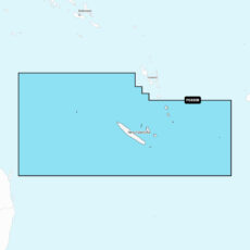
Garmin Navionics + Chart: PC030R – New Caledonia
Detailed coverage of the northern and western coasts of Australia from Darwin to Ceduna. Includes coverage of Perth, Bunbury, Geraldton, Broome, Esperance, Dampier, Shark Bay and the Ashmore and Cartier Islands.
- Garmin
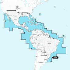
Garmin Navionics + Chart: SA004L – Mexico, Caribbean to Brazil
Coastal coverage of Mexico, Central America and Brazil. Coverage includes the US Gulf Coast and the eastern US coast to Savannah, GA; Bermuda; the Bahamas; Cuba; Hispaniola; Puerto Rico and the Virgin Islands; the Windward and Leeward Islands; Jamaica; the Panama Canal, the western coast of South America to Arica, Chile; the Galapagos Islands; the Revillagigedo Islands; the Ilha Fernando …
- Garmin
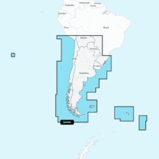
Garmin Navionics + Chart: SA005L – Chile, Argentina & Easter Isl
Coastal coverage of South America from Arica, Chile to Rio Grande, Brazil. Coverage includes Easter Island, Cape Horn, the Falkland Islands/Islas Malvinas, the South Georgia Islands, the South Sandwich Islands and the Rio de la Plata.
- Garmin
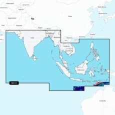
Garmin Navionics Vision+ Chart: AE010L – Indian Ocean & S China Sea
Coastal coverage of the South Asian coast and the Indian Ocean from Gwadar, PK to Da Nang, VN and the South China Sea. Includes India, Ceylon, Bangladesh, Myanmar, Thailand, Malaysia, Singapore, Cambodia, Indonesia, Brunei, the Philippines, the Andaman and Nicobar Islands, the Cocos Islands, Christmas Island, and the Maldives. Lakes Pangong and Spanggur are also covered.
- Garmin
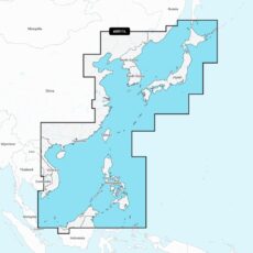
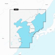
Garmin Navionics Vision+ Chart: AE011L – China Sea & Japan
Coastal coverage of the eastern Asian coast from Vladivostok, RU to the Mekong River Delta. Coverage includes the Japanese Islands, the Korean Peninsula, Taiwan, Brunei and the Philippines and the ports of Shanghai, Dalian, Hong Kong and Pusan.
- Garmin
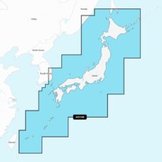
Garmin Navionics Vision+ Chart: AE016R – Japan
Detailed coverage of coasts of Japan: from Yaeyama Islands, Okinawa to Aniva Bay and Kunashir Island. Coastal coverage of South Korea from Busan to Deoksan-ri. Includes detailed coverage of most major lakes including Inawashiro, Kussharo, Ogawara, Onuma, Shikotsu, Shinji, Towada, and Toyako.
- Garmin
Garmin Navionics Vision+ Chart: AE018R – Yellow Sea
Coastal coverage of the East Asian coast from Vladivostok, RU to Shanghai, CH including the Korean Peninsula. Coverage includes the ports of Busan, South Korea and Dalian, China.
- Garmin
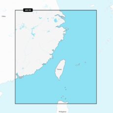
Garmin Navionics Vision+ Chart: AE019R – Taiwan
Coastal coverage includes mainland China from Shanghai to Hong Kong and Taiwan. Included in this coverage are detailed charts covering areas such as Macau, Keelong, Kaohsiung, Xiamen, and Guangzhou in China and Kaohsiung, Taichung City and Taipei in Taiwan.
- Garmin
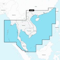
Garmin Navionics Vision+ Chart: AE020R – South China & Andaman Seas
Coastal coverage of the East Asian coast from Xiamen, China to Thailand including the coast of Vietnam, Cambodia, the Malay Peninsula, Hainan Island and the Andaman and Nicobar Islands. Included are detailed charts of such areas as Hong Kong and Macau; Phuket, Thailand; Singapore; Ho Chi Minh City, Vietnam and Guangzhou and Xiamen, China.
- Garmin
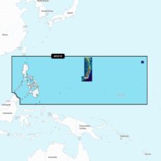
Garmin Navionics Vision+ Chart: AE021R – Philippines
Coastal coverage of the Philippine Islands and islands of Micronesia including the Marianas, Palau, Guam, Saipan and Wake Island.
- Garmin
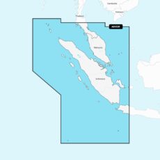
Garmin Navionics Vision+ Chart: AE022R – Sumatra
Coastal coverage of the Malay Peninsula from Phuket, Thailand to Singapore and portions of Indonesia including Java and the entire island of Sumatra. Coverage includes Christmas Island, the Cocos Islands and ports such as Jakarta, Indonesia and Malacca and Kuantan, Malaysia.
- Garmin
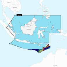
Garmin Navionics Vision+ Chart: AE023R – Java & Borneo
Coastal coverage of the central Indonesian islands and portions of Malaysia and the Philippines. Coverage includes Java, Borneo, Sulawesi and islands west of Timor, Brunei and the ports of Singapore, Jakarta and Davao City.
- Garmin
Garmin Navionics Vision+ Chart: AE024R – Central W Papua & E Sulawesi
Coastal coverage of Indonesia southeast and east of Sulawesi including East Timor and the ports of Surong, Manokwari, Manado, Makassar and Kendari.
- Garmin
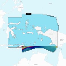
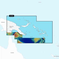
Garmin Navionics Vision+ Chart: AE025R – Papua New Guinea & Solomon Is
Coastal coverage of Papua New Guinea and the Solomon Islands. Ports include Lae, Rabaul and Port Moresby, Papua New Guinea and Honaira, Solomon Islands.
- Garmin
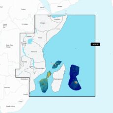
Garmin Navionics Vision+ Chart: AF001R – Africa, East
Coastal coverage of the east coast of Africa from Maputo Bay to the Horn of Africa, Zanzibar, Madagascar, Mauritius, Reunion and the Seychelles. Coverage includes the ports of Maputo, Mozambique; Dar es Salaam, Tanzania and Mombasa, Kenya.
- Garmin
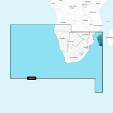
Garmin Navionics Vision+ Chart: AF002R – Africa, South
Coastal coverage of southern Africa from Namibe, Angola to the Zambezi Delta in Mozambique. Includes detailed coverage of Cape Town, Port Elizabeth, East London and Durban in South Africa and Maputo, Mozambique. Also includes coverage of the Tristan da Cunha Islands, St. Helena Island, Gough Island and the Prince Edward Islands.
- Garmin
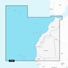
Garmin Navionics Vision+ Chart: AF004R – Africa, Northwest
Coastal coverage of the northwest coast of Africa from St Louis, Senegal to Rabat, Morocco. Detailed coverage of the Azores, Madeira, the Canary Islands, the Cape Verde Islands and the ports of Rabat and Casablanca, Morocco are included.
- Garmin
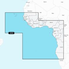
Garmin Navionics Vision+ Chart: AF005R – Africa, West
Coastal coverage of the west coast of Africa from Dakar, Senegal to Cape Cross Bay, Namibia. Detailed coverage of the Cape Verde Islands, Sao Tome and Principe, St Helena Island and Ascension Island and the ports of Dakar, Senegal; Lagos, Nigeria and Luanda, Angola are included.
- Garmin
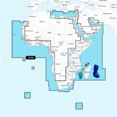
Garmin Navionics Vision+ Chart: AF630L – Africa & Middle East
Coastal coverage of the coast of Africa from Tripoli, Libya thru the Red Sea and around the Cape to Dakar, Senegal including the Suez Canal and the Levant, the coast of the Arabian Peninsula, the Persian Gulf, Madagascar, Socotra, Zanzibar, Reunion, Mauritius, the Seychelles, the Comoros, the Prince Edward Islands, Tristan de Cunha, St Helena Island, Ascension Island, the Cape …
- Garmin
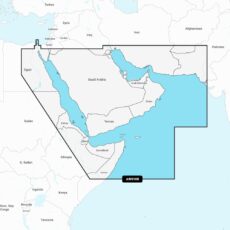
Garmin Navionics Vision+ Chart: AW010R – The Gulf & Red Sea
Coastal coverage of the Arabian Peninsula, the Red Sea and the Persian Gulf including the Suez Canal, the Gulfs of Aden and Oman, the coasts of Iran and Pakistan. Numerous detailed charts are included of areas such as Port Said, Egypt; Djibouti; Dubai; Bahrain and Karachi, Pakistan.
- Garmin
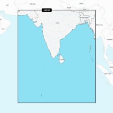
Garmin Navionics Vision+ Chart: AW015R – Indian Subcontinent
Coastal coverage of the Indian subcontinent from Pasni, Pakistan to Sittwe, Myanmar including Sri Lanka, the Andaman and Nicobar Islands, the Chagos Archipelago and the Maldives. Coverage includes ports such as Karachi, Pakistan; Calcutta and Mumbai, India and the Male Atoll.
- Garmin
Garmin Navionics Vision+ Chart: PC012L – Australia & New Zealand
Detailed coverage of Australia, New Zealand and many associated islands. Coverage includes the Great Barrier Reef, Tasmania, Christmas Island, the Cocos (Keeling) Islands, Norfolk Island, Campbell Island, the Auckland Islands, the Antipode Islands, the Bounty Islands, the Chatham Islands and the Kermadec Islands. Ports include Sydney, Melbourne, Perth, Darwin and Cairns in Australia; Wellington, Auckland, Nelson and Dunedin in New …
Garmin
Showing 589–616 of 889 results